This post is about the Northern plains of India. This post is very important from the examination point of view.
Also Check: Volcanoes, types and distribution.
Also Check: Cropping patterns and major crops of India
Also Check: President of India, All Details
Northern Plains of India
- The Great North Indian plain lies to the north of the peninsula and to the south of the Himalayas.
- So, it is a transitional zone between Himalayas and Peninsular India.
- The plain extends for 3200 km between the mouths of the Ganga and the Indus, all along the foot of the mountains, with a width varying from 150 to 300 km.
- The plain is narrowest in Assam with its width varying between 90 and 100 km.
- It is 160 km wide near the Rajmahal hills and 280 km near Allahabad.
- It is widest in Punjab with a width of around 500 km.
- The plains were formed as a result of the filling of depressions ( aggradational plane) lying between the peninsula and the Himalayas by the depositional work of the Himalayan rivers Ganga, Brahmaputra, Indus and their tributaries.
- The Northern plains are homogenous to a remarkable extent, having an imperceptible slope and little variety in its geomorphological features.
- However, at a smaller level, there are some discontinuities caused by river bluffs, Bhurs, levees, dead-arms of river channels, the ravines and kiwis.
- These plains are also known an Indo-Gangetic plains, Ganga Brahmaputra plains and Great Indian plains.
Physiographic Divisions of the Northern Plains of India
Generally, the plain is recognized as consisting of four physiographic divisions, each characterized by important differences in surface relief.
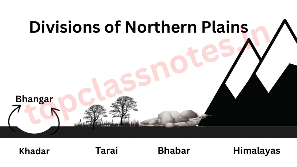
(1) Bhabar
- The Bhabar is a narrow belt of 8–16 km wide running in an east-west direction along the foothills of the Shiwaliks.
- It extends from Jammu Division in west to Assam in the east.
- The Himalayan rivers deposit their sediments, creating alluvial fans along the foothills. The fans, consisting of gravel and unsorted boulders and rocks, merge together to form the Bhabar belt.
- It shows an excellent continuity from Indus to Tista.
- The presence of rocks, pebbles and boulders in Bhabar zone turns it into porous beds.
- The porosity is so high that all streams almost disappear in the Bhabar region. Therefore it is marked by dry river courses, except during rainy seasons.
- It is not important for agriculture or forestry. Only such trees which have deep roots can survive in this region.
(2) Terai
- It lies to the south of the Bhabar region.
- The rivers and streams that disappeared in Bhabar region re-emerge in this region.
- The Terai is a marshy tract south of the Bhabar marked by the re-emergence of underground streams of the Bhabar belt.
- These streams convert large areas along the rivers into marshy lands of excessive dampness.
- It is widest in Bihar and narrows down as one moves towards east.
- Much of it has been reclaimed for agricultural purposes, and crops like sugarcane, wheat and rice are grown on such reclaimed land.
(3) Bhangar
- The Bhangar refers to the upland formed by the deposition of older alluvium in riverbeds.
- It is an alluvial terrace above the floodplains, often impregnated with calcareous concentrations known as kankar.
- Soil texture varies from loamy to clayey loam.
- rich in humus, phosphoric acid, lime and organic matter. deficient in potash.
- It contains fossils of many extinct species like two horned rhinos.
(4) Khadar
- Low lying, frequently experiences floods and therefore receives new silt (alluvium) frequently.
- The Khadar is composed of newer alluvium and forms the floodplains along the riverbanks.
- It is in this region that the world’s largest delta Sunderban delta has been formed.
Differences Between Khadar and Bhangar
| Feature | Khadar | Bhangar |
|---|---|---|
| Nature | Newer and younger deposits of the floodplains. | Older alluvium found higher up in the plains at river terraces away from rivers. |
| Fertility | More fertile as new layers are deposited every year during monsoonal floods. | Less fertile as it is not renewed. |
| Soil Composition | Loamy and porous soil. | Clayey and non-porous soil. |
| Color | Pale brown, sandy clays, and loams; more dry and leached, less calcareous and carbonaceous. | Dark-colored with a more clayey composition. |
Regional Divisions of Great Indian Plains
The Great Indian Plains of North India can be divided into the following four major regions:
- The Rajasthan or Western Plains
- The Punjab-Haryana Plains
- The Ganga Plains
- The Brahmaputra Plains
1. The Rajasthan Plain
- It is an undulating plane with an average elevation of about 325 m above sea level.
- This plain consists of the Thar or Marusthali and the arid plain of Rajasthan.
- Luni is the only river flowing through this desert region.
- North of the Luni basin, there is a large area of inland drainage.
- The eastern Thar Desert has several saline lakes such as Sambhar, Didwana, Degana, Sargol, and Khatu.
- Sambhar is the largest salt lake in India.
2. The Punjab-Haryana Plain
- This part of the plain is formed as a result of deposits brought by five rivers (Satluj, Ravi, Chenab, Jhelum, and Beas) and is known as Punjab.
- It is primarily made up of Doabs (interfluves) – the land between two rivers.
The important Doabs in this plain are:
- Bist-Jalandhar Doab – Between Beas and Satluj.
- Bari Doab – Between Beas and Ravi.
- Rechna Doab – Between Ravi and Chenab.
- Chaj Doab – Between Chenab and Jhelum.
- Sindsagar Doab – Between Jhelum, Chenab, and Indus.
3. The Ganga Plain
- The plain stretches between Punjab-Haryana Plain to the Sundarbans Delta region.
- The Ganga, along with Yamuna, Gomti, Ghaghara, Gandak, and Kosi, has deposited large quantities of alluvium to build this fertile and densely populated region.
The important Doabs in this plain are:
- Ganga-Yamuna Doab
- Ganga-Ghaghra Doab
- Ghaghra-Gandak Doab
- Gandak-Kosi Doab (Mithila Plain)
- The Ganga Plain is further divided into the Upper Ganga Plain, Middle Ganga Plain, and Lower Ganga Plain.
4. The Brahmaputra Plain
- Aldo known as Assan valley plains.
- It is an aggradational plain built up by the depositional work of the Brahmaputra and its tributaries.
- It is girdled by Purvanchal hills, Patkai Bum, Naga Hills in the east, Garo-Khasi-Jaintia, Mikir Hills, and Meghalaya Plateau in the south.
- Several islands have originated because of the deposition of soil in the middle of the Brahmaputra, with Majuli being one of them. Majuli is the largest riverine island in the world.
Also Check: Peninsular Rivers of India
Significance of Northern Plains
- It makes almost one fourth of India’s total land area and is home to almost half of India’s population.
- Due to featureless toppgraphy, lot of rivers, fertile soils and favourable climate, it is the hub of agricultural activities.
- Its location (to the North of Tropic of cancer) makes it a feasible for both Kharif as well as Rabi crops.
- Such intense agricultural activities along with the extensive irrigation facilities has helped Punjab, Haryana, and western Uttar Pradesh become the “granary of India.”
- The featureless topography has enabled well-connectivity by roads and railways, leading to industrialization and urbanization.
- Rich in cultural tourism:
- Sacred rivers like Ganga and Yamuna attract Hindus.
- Birthplace of Buddhism, Jainism, Bhakti, and Sufi movements.
So, this was all about the Northern plains of India. Now lets solve some MCQs.
MCQs on Northern Plains of India
The following MCQs are very important from the examination point of view. Solve them to perform better in your exams.
The northern plains are also known as:
- Ganga Brahamaputra plain
- Indo Gangetic plain
- both
- none
both
Which of the following rivers make the northern plain of India?
- Ganga
- Brahamputra
- Indus
- Kaveri
- all of them
- only 1,2 and 3
- only 1 and 2
- only 2, 3 and 4
only 1,2 and 3
The great plains of India are separated from Shiwaliks by?
- Himalyan frontal fault
- main central thrust zone
- main boundary thrust
- none
Himalyan frontal fault
What is the stretch of the Northern Plain from east to west?
- 2400km
- 3000km
- 2050km
- 2800km
2400km
What happens to the width of the northern plain in general, as we move from east to west?
- it increases
- it decreases
- it remains constant
- it decreases and then remains constant
it increases
Which of the following has very low relief.
- Northern plain
- Himalyas
- western Ghat
- eastern ghats
Northern plain
Analyze the following table and check which one among the options matches with A,B,C,D
| A. Bhabar | 1. Younger alluvium |
| B. Terai | 2. It is very porous |
| C. Bhangar | 3. Has thick forest cover and wild life |
| D. Khadar | 4. Older Alluvium |
- 2,3,4,1
- 1,2,3,4
- 3,2,1,4
- 4,3,2,1
2,3,4,1
In which of the following do the streams of water disappear owing to its high porosity?
- bhabar
- khadar
- bhangar
- tarai
bhabar
Which of the following is marshy in nature?
- Bhabar
- Tarai
- Bhangar
- Khadar
Tarai
In which of the following are concretions called “kankars” found?
- Bhabar
- Tarai
- Khadar
- Bhangar
Bhangar
Which of the following is the most productive part of the northern plains?
- Bhabar
- Khadar
- Tarai
- Bhangar
Bhangar
Which of the following are the tracts of new alluvium?
- bhabar
- khadar
- bhangar
- tarai
tarai
Sunderban delta is formed by?
- Krishna and Kaveri
- Ganga and Brahamputra
- Brahamputra and Mahanadi
- Indus and Ganga
Brahamputra and Mahanadi
The uplands and the marshy areas in Delta plains are respectively known as:
- chars and bills
- chars and bets
- khols and bils
- none
chars and bills
The plains of Rajasthan have a total area of?
- 175000 sq km
- 275000sq km
- 375000 sqkm
- 100000 sq km
175000 sq km
Which among the following statements regarding the Great Plains of India is/ are true?
- The Great Plains of India are located to the north of the Shiwalik
- They are the alluvial deposits of rivers.
- The average depth of the alluvium deposits increases from south to north.
Choose the correct option from the codes given below:
- all of them
- only 1 and 2
- only 2 and 3
- only 1 and 3
only 2 and 3.
Which among the following statements about the Bhabar plain are correct?
- It is located to the south of the Shiwalik and north of the Tarai tract
- Due to its high porosity, all small streams disappear here
- This place is highly suited for agriculture
- it is around 8 to 15 km in width
- all of them
- only 1 ,2 and 4
- only 1, 2 and 3
- only 1,3 and 4
only 1 ,2 and 4
In Punjab, the Khadar rich flood plains are locally known as?
- Bets.
- bils
- bhur
- char
Bets.
So, this was all about the topic. We are sure that you will share this article with your friends.